
Saturday, August 30, 2008
Valley Bennett Dam outflow
This puzzle picture was taken south of Bennett dam. To read the related blog click on the title.
Sunday, June 15, 2008
Bennett Dam
 On Sunday June 22nd Gord Jarvie, Doris, and myself drove the scenic route to Bennett Dam. The week before I flew over the dam with my son Shaun. I think they need to provide a landing strip so we could visit more often without the long car ride.
 To the right of the dam you can see the 10 large columbs that are the inlets for the 10 turbines. The blue "cabin" on this end can travel across to each inlet and is equiped with the ability to block any one inlet to allow maintanance work. Williston Lake in the background is the biggest lake in B.C. ( Man made or otherwise.) It is 250 miles long and averages 3 miles wide.
 This is looking down from the northern look-out over the dam outlet. From here the water travels aproximatly 20 km. to the Peace Canyon Dam where the water is re-used to generate more power. Site "C" is in the planning down stream. When traveling the valley from Fort St. John one can see signs indicating high water levels thoughout the canyon. Another huge lake will be created with this third phase of dams.
The earth filled dam was made from material found 5 miles down stream and was transported to the dam site via the longest conveyer belt in the world. The centre consists of fine sand which is held in place with larger rock placed on either side. The dam is 2 km. long and 183 meters high, 800 meters wide at it's base, and 9 meters wide at top and contains enough material to build a wall 4 meters wide and 4 meters high from Vancouver to Halifax.
 The picture above was taken from the viewpoint parking lot on the north side of the dam. The picture below was taken several days earlier from the air in my plane. I found it very interesting how simular they were. Just above the left outflow you can see a portal where we traveled in a bus into the dam 500' below the water level. We then walked into the generating room which is three football fields long and
 The W.A.C. Bennett Dam, completed in 1967, was a colossal project in its time and remains one of BC's most impressive to date. As one of the world's largest earth-filled structures, the dam impounds BC's largest reservoir - 1,761-sq km (680-sq mi) Williston Lake, which took five years to fill!
On our way to "tour" the dam from the air we flew through several small rainstorms. They lasted for a very short time.
 We were flying quite low towards the mouth of the dam. We flew through another 30 second rain storm. The dam itself is situated between a narrow valley. This is the beginning of that valley.
Rounding the corner this channel of water leads to the spillway of the dam.

You can enlarge the pictures by clicking on them.

The small valley opens up to the dam edge.
 Here you can see two of the three tunnels that were built to devert the river creating a dry river bed to build the dam on. They no longer have a function. Just left of the picture there is a concrete spill way where water can be released should the dam become too full. The spillway turns up at the end to send water into a "spray" so as to control erosion. For some reason I don't have a picture of this.
W.A.C. Bennett Dam and generating station form the larges hydroelectic facility in B.C. Hydro's system, with the capacity to product more than 2,730,000 kilowatts of electric power. There are over 30 dams in BC and the Bennett dam together with Peace provide 30% of all of B.C's power.


 The town of Hudson Hope is situated approx. 16 km east of the Bennett Dam. We thought we would stop at the airport and stretch our legs. This is the largest building at the airport. It is at an elevation of 2,200' above sea level.
My son Shaun came with me on this flight.

Here is my baby sitting on the tarmack at Hudson Hope airport.

The run way has a few cracks in it.

Taking off from the airport i took some pictures of the town of Hudson Hope. It's a quaint little town situated along the rivers edge. Looks like a town where I would like to live. One would think the existance of Hudson Hope began because of the dam construction. However Hudson Hope existed long before. Hudson Hope is B.C.'s third oldest community. Current population is 1000.

Dawson Creek welcomed us back with a rainbow! If you wish to know more about the Bennett dam click on this blogs title. This will link you to BC Hydro's Bennett dam web site. Have a GREAT day my friends.
Monday, March 10, 2008
Louisiana Pacific
Louisiana Pacific, ( LP), is an OSB plant in Dawson Creek BC. If you would like to read some interesting facts about this company just click on the tital to be taken to their home page. There are three large OSB plant within 1 1/2 hrs drive of Dawson Creek. One in Fort St. John and also one in Grand Prairie.

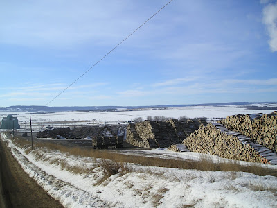
The amount of trees one of these plants goes through is beyond comprehension. The picture below was taken from almost 2000' above ground. There are three piles of Poplar logs. The building is very large yet dwarf ted by piles of logs. 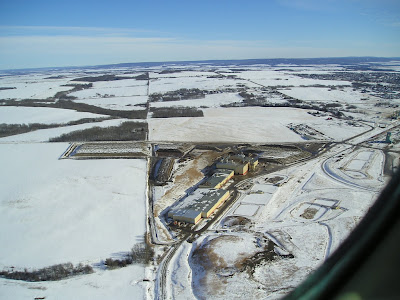 You can enlarge the pictures by clicking on them. This shot was taken from another angle about 1000' above ground.
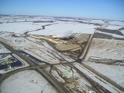
 Another shot of the same area. I thought my camera batteries were dead but i guess I got a few off. :-) The train tracks are brought right up to the building and may even enter.
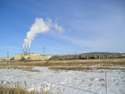
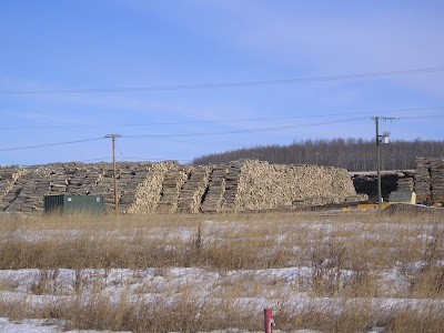
This picture was taken from the Alaska highway. It gives a little more perspective as to how big these piles of logs really are.
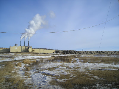
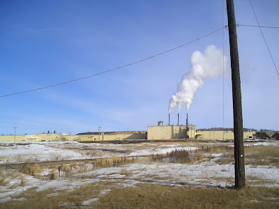
Flying into the vicinity of Dawson Creek it is easy to get oriented as to where you are by the plumb of steam rising from the plant on the north edge of town. This plant is located 3 miles from mile "0" of the Alaska highway.
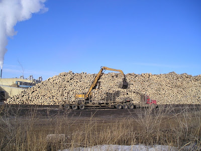
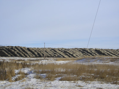
While I was taking pictures from the road I observed six "B" train logging trucks arrive to be unloaded.

I also observed at least two of these large hoes, with grapples, unloading trucks. Large bundles were unloaded at a time.
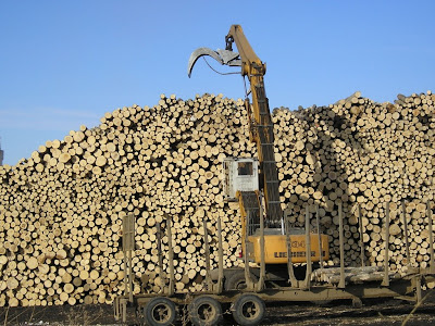
Reaching up to pile the logs as high as they could. I would estimate a lot of the pile to be over 20' high.
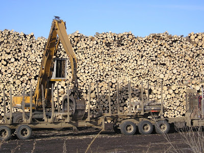

Looking down the road it seemed that the piles went on forever!


The large building just disappears behind the logs. You wouldn't know it was there if not for the plumb of steam.


 You may have to click on the picture below to see the logs rising above the back of the building.
 As you can see spring is just around the corner. The snow is disappearing. I'm ready for it!!
 You can enlarge the pictures by clicking on them. This shot was taken from another angle about 1000' above ground.
 Another shot of the same area. I thought my camera batteries were dead but i guess I got a few off. :-) The train tracks are brought right up to the building and may even enter.
This picture was taken from the Alaska highway. It gives a little more perspective as to how big these piles of logs really are.

Flying into the vicinity of Dawson Creek it is easy to get oriented as to where you are by the plumb of steam rising from the plant on the north edge of town. This plant is located 3 miles from mile "0" of the Alaska highway.


While I was taking pictures from the road I observed six "B" train logging trucks arrive to be unloaded.

I also observed at least two of these large hoes, with grapples, unloading trucks. Large bundles were unloaded at a time.

Reaching up to pile the logs as high as they could. I would estimate a lot of the pile to be over 20' high.


Looking down the road it seemed that the piles went on forever!


The large building just disappears behind the logs. You wouldn't know it was there if not for the plumb of steam.


 You may have to click on the picture below to see the logs rising above the back of the building.
 As you can see spring is just around the corner. The snow is disappearing. I'm ready for it!!
Monday, February 18, 2008
New Intercom

During my last flight home I lost the ability to transmit through my radio. Before spending a lot of money having someone look it over I made several attemps to correct the problem myself. That didn't work so I decided to purchase a new intercom and see if that corrected the problem. I wanted a new one anyway, expanded so my back passengers would also be included in the conversations.
I received my new intercom before Christmas. I did take it to the airport and tested it. It seemed I could now send but receiving was very faint. I didn't want to sit in the cold and see if i could get it working so put it off until today. I hooked it all up and was thrilled to hear a loud clear voice talk back to me.
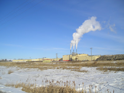
 I finished a quick pre-flight check and fired up the new engine which hasn't run for nearly 4 months. It fired right away and ran smoothly. I let it warm up and applied full power to start moving. Unfortunately small ruts had formed and frozen under the wheels and i didn't have enough power to drive out. I shut it down, got out my handle, and pulled the plane sideways till one wheel was out of it's rut. Then pulled the other way to clear the other wheel. Then I climbed in, fired up and easily moved to the tarmac, received clearence, and took off. This picture is taken from 2000' above ground of LP. A OSB sheathing plant. The buildings are very large yet are dwarfed by the four piles of logs. You will have to click on the picture to enlarge it to make out the log piles. These piles are over 16' high and is the most logs i've ever seen in one place.
 I started my flight by remaining in the circuit and completing 3 landings before flying off over the city. The wind was gusting at 20knts but was directly in line with the runway. Which did make for wonderful lift on take-off. I climbed at 1200' per min. On the approch for runway 24 there are several ravines which causes quite a bit of mechanical turbulance when there is air movement. Compensating for windy conditions quickly came back to me. Satisfied that i could still land an airplane I headed for the open sky.
 You can see, from these pictures, why this area is called: "Big Sky Country!" The weather was sunny and warm. I flew most the entire trip with the heat off and window open. I flew over some friends house to see if they were home. Flying low when windy is difficult as mechanical turbulance increases near the ground. Also your speed must be kept up so one fly's by very quickly. I proceeded North towards Ft.St.John to another friends house. I flew over his 800 acres looking for the spot by the river that he wants to build a hunting cabin. Then I flew for home.
Over my left wing you can see all of Dawson Creek. I love it that you can access anything in town within 10 min. :-) To cross Abbotsford can take you more than half an hour. Flying here, with the wind behind me, I gave full throutle to see how fast I could travel in straight and level flight. My GPS clocked up to 145knt. per hr. ( 163 mph or 264 kmph. ) in ground speed. I landed, tied down the aircraft, put it's cabin tarp on, and headed home. It was good to be up again.
Subscribe to:
Posts (Atom)